


La Mézière A+ Reco

nolsim
User
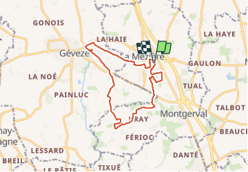

Length
13.2 km

Max alt
105 m

Uphill gradient
145 m
Km-Effort
15.1 km

Min alt
55 m

Downhill gradient
146 m
Boucle
Yes
Creation date :
2023-12-02 08:20:44.792
Updated on :
2023-12-02 11:08:18.343
2h40
Difficulty : Easy

FREE GPS app for hiking
 SityTrail
IGN / Geographical institutes
SityTrail Plus
The world is yours!
About
Trail Walking of 13.2 km to be discovered at Brittany, Ille-et-Vilaine, La Mézière. This trail is proposed by nolsim.
Photos


Positioning
Country:
France
Region :
Brittany
Department/Province :
Ille-et-Vilaine
Municipality :
La Mézière
Location:
Unknown
Start:(Dec)
Start:(UTM)
592872 ; 5341201 (30U) N.
Comments